Some Sashizu (drawings) are included in the Toji Hyakugo Archives. One of them is a Shoen Ezu (lit. pictorial diagram of manor) titled “Settsunokuni Taruminosho Sashizu” (Item 101 of Box-U (Katakana)).
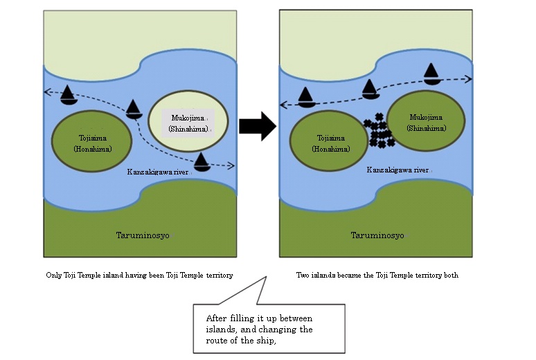
This picture depicts a Shoen (manor) that was located in around the present Suita, Osaka, showing rivers and farm fields throughout Taruminosho. At a close look, some things are drawn between the two islands that are located in the Mikunigawa river (present Kanzakigawa river), which runs from east to west at the top of the picture.
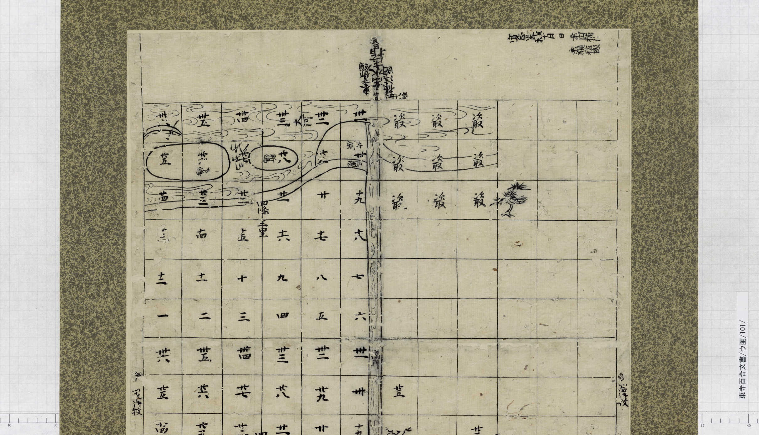
* Care should be taken as to the directions. In this drawing, the top is directed to the south, and the bottom to the north.
These things look like plants or trees… what are they? The true answer is in another document in the Hyakugo Archives.
In “Nijuikku-kata Hyojo Hikitsuke (廿一口方評定引付)”, minutes of meetings held by monks at the Toji temple, there is an article dated September 2, 1463 , which mentions Mikunigawa and these two islands/sandbanks.
According to this article, the larger island (Honshima (本島)) was a part of Taruminosho as an estate of Toji, while the other island on the right (Shinshima (新島), called “Mukojima (向島)” in the article above) belonged to a different owner.
Enoki Keitoku (榎木慶徳), a.k.a Enoki Nyudo (榎木入道), who was the former Daikan (local magistrate) for Taruminosho thoroughly filled the gap between the two islands with firewood piles that were topped by willow branches, thereby reclaiming the stream!
Thus the channel between the two islands, through which boats used to pass, disappeared, and one whole larger island was made. Why did Enoki Nyudo do this?
He conducted this reclamation for the purpose of preventing boats from passing between the islands, and allowing them to travel only on the south of the newly made island.
In “Draft Letter by Enoki Keitoku (榎木慶徳書状案)” (Item 262 of Box-NA(Hiragana), there is a passage that describes a custom concerning the Yodogawa river, as to the ownership of a sandbank/island in a river.
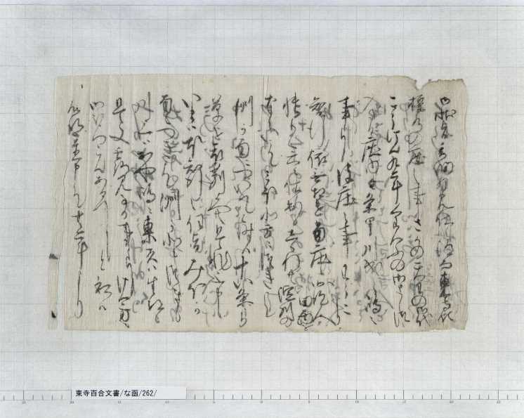
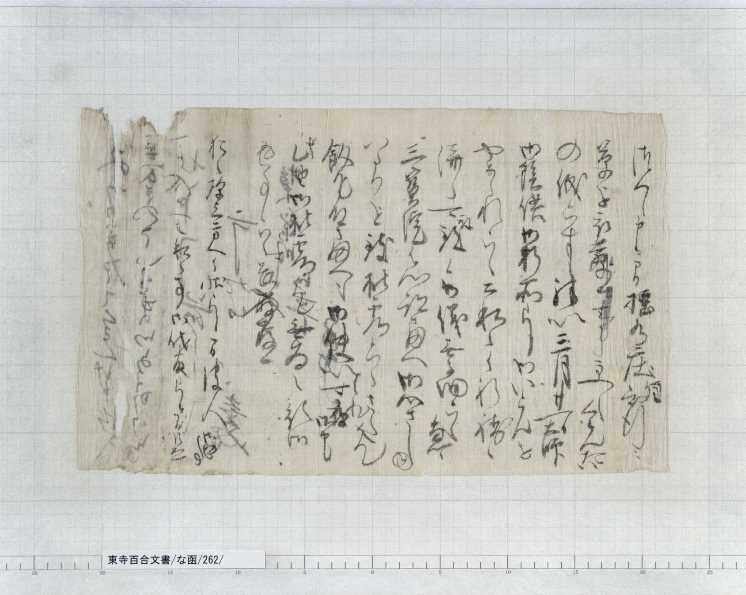
The passage states that, if there is a vessel route in the south of a sandbank, that sandbank belongs to the domain in the north of the river, and vice versa.
In other words, the route of boats was simply interpreted as the border of a domain.
Enoki Nyudo conducted the work to change the vessel route to the south of the island, by filling the gap between the two islands with firewood and pillow, so that Mukojima/Shinshima would be included into Taruminosho, which was located in the north of the river.
Another river that ran through Taruminosho from north to south (present Takagawa) flew right into the north of the island, where a sandbar was easily formed. Thus boats had no other choice to travel in the south of the newly made island. It seems a little high-handed approach!
Now you know the answer to the earlier question: the things that were drawn between the two islands in “Settsunokuni Taruminosho Sashizu” (Item 101 of Box- U (Katakana)) were artificial reclamation with many firewood piles topped with willow branches.
★ Below are graphical representations of the process above, also the top directed to the south and the bottom to the north:
There is another Shoen Ezu titled “Settsunokuni Taruminosho Zu”, included in the Kyoo-Gokoku-ji Documents, which are owned by the Kyoto University Museum. These documents were also been handed down in the Toji temple, a.k.a Kyoo-Gokoku-ji, just like the Toji Hyakugo Archives. This drawing depicts Mikunigawa at about the same time as “Settsunokuni Taruminosho Sashizu” ( Item 101 of Box-U (Katakana)).
In this drawing as well, the top is directed to the south, and the bottom to the north.
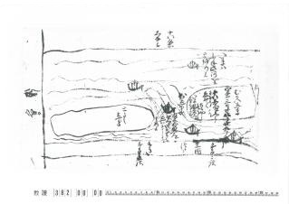
This picture also shows two islands located in the river. Honshima is marked as “Toshi (i.e. Toji) shima”, and Shinshima as “Mukojima”.
Many boats are also depicted. In those days, not only Yodogawa, but also Mikunigawa was an important waterway that connected Osaka Bay with the Kyoto Basin, through which a large number of vessels traveled. Land tax from Shoen in different parts of Kansai was also delivered to Toji through this river.
Originally, boats used to travel through the north of Mukojima, between the two islands, and in the south of Toshishima.
In this picture, there is a boat drawn between the islands, but beneath it is written that Enoki Nyudo thoroughly filled the gap between the islands with firewood topped with willow branches (“榎木和泉入道せつせつにやなきをしはにさしたてうめ候”). In the top right of the drawing, to the south of the island, it is noted that boats passed through the south of the island after the reclamation (“いまはふね此河をとをり候”).
Now that the stream between the islands was reclaimed, vessels had no other choice than to pass in the south of the former two islands. This totally matches the article dated September 2, 1463, in “Nijuikku-kata Hyojo Hikitsuke”!